| Miles |
Kilometers Miles multiplied by 1.61 equal kilometers. |
| 0.0mi | 0.0km | Pick up passenger at "Arrivals" under glass dome. Bear right (south) until merge with 4-lane Airport Way. Continue south on Airport Way. |
| 2.3mi | 3.7km | Turn right onto I-205 South. Follow signs to "Portland/Salem". |
| 5.5mi | 8.86km | Turn right onto I-84 West to Portland, Exit 21B. |
| 11.3mi | 18.19km | At the Y where I-84 freeway splits, bear left taking I-5 South to Salem. For first 300 yards, bear left, staying on I-5 South. |
| 12.4mi | 19.96km | When you are up on the bridge overlooking the Willamette River, the freeway splits again. Take the right lanes to I-5 South to Salem. Continue on "I-5 South to Salem". |
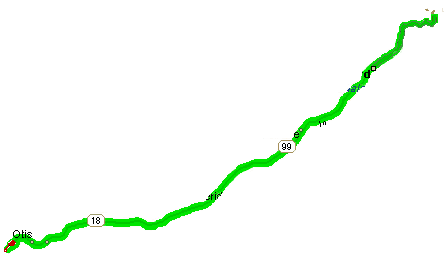
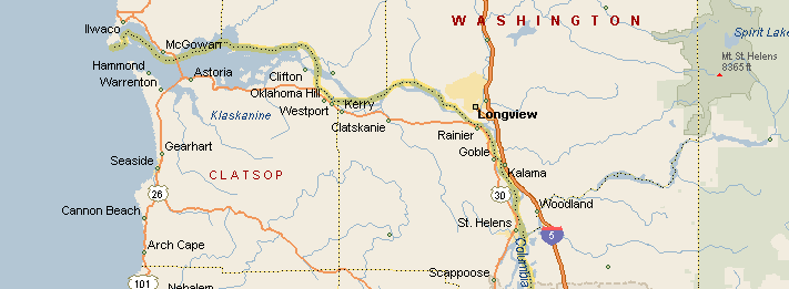
| 18.8mi | 30.27km | Take Exit 294 off I-5 freeway, turning onto Hwy 99W. Signs will say Tigard/Newberg; McMinnville/Lincoln City/Ocean Beaches. Continue on Hwy 99W until it intersects with Hwy 18 going toward the coast. You will pass through Tigard, King City, Tualatin, Sherwood, and Newberg.
In Newberg, at one point the 4 lanes split, westbound lanes take a right turn for 1 block, then turn left. Just keep going, making a slow gentle turn to the left until the road becomes 99W again on the west edge of Newberg. After 2 more miles, you will enter Dundee, a small country town where the road narrows to 2 lanes, creating the main traffic bottleneck between Portland and the Oregon coast, especially on Friday and Sunday afternoons and evenings.
You will be driving through the Oregon Wine Country. Watch for signs bearing names of wine galleries open for tours and tastings. |
| 41.2mi | 66.33km | Turn left off Hwy 99W onto Hwy 18. Signs will say "18 223 Dayton Oregon Coast". A fresh fruit and veggie open air market will be on your left and an RV sales company on your right as you turn left onto Hwy 18. |
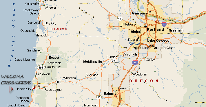
| 44.0mi | 70.84km | You could consider taking a 2-mile side trip to Lafayette Antique Mall. |
| 46.0mi | 74.06km | Continuing on Hwy 18, youll be skirting central McMinnville. Youll pass McMinnville Airport and Evergreen Aviation on your left.
On your right, youll see the new glass home of the "Spruce Goose", built in the 1940s, first flown in 1947, it was intended to transport large quantities over long distances, to be able to transport material to England by flying over enemy ships during World War II.
A Howard Hughes and Henry Kaiser effort, decades ahead of its time in the 1940s, it is still the biggest aircraft ever built. Open to the public for tours 9am to 5pm: www.sprucegoose.org |
| 47.2mi | 75.99km | Outlet stores on your right. Save your time and money for Lincoln Citys 65 factory stores, just a mile and a half from  . . |
| 47.7mi | 76.80km | At the Y in the road, bear left to stay on Hwy 18 to the coast, instead of heading back toward central downtown McMinnville. |
| 49.2mi | 79.21km | Do NOT take turnoff for 99W to Corvallis. |
| 57.2mi | 92.09km | Lawrence Gallery and Fresh Palette Café. Wonderful places. Stop here some time. |
| 61.5mi | 99.02km | Federal Correctional Institute (Prison) on the left. Red roofs, white walls. |
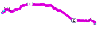
| 67.0mi | 107.87km | Hwy 22 coming from Salem merges into Hwy 18 from the right lanes. |
| 70.2mi | 113.02km | Texaco gas station on the right. If youre low on gas or need to make a potty stop, here is the last fairly decent place before you reach the coast. |
| 71.7mi | 115.44km | Spirit Mountain Casino. Wonderful place. But save your time and money for the Chinook Winds Casino and Convention Center in Lincoln City, just three-fourths of a mile north of beach house. |
| 75.6mi | 121.72km | Entering Van Duzer Corridor of old growth forest. |
| 85.6mi | 137.82km | Leaving Van Duzer Corridor of old growth forest. |
| 93.0mi | 149.73km | Otis Café. Tiny but good, again, after an interlude between changes in ownership. |
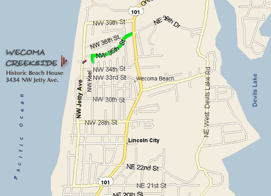
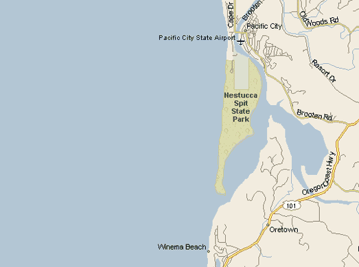
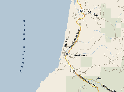
| 94.0mi | 151.34km | Junction of Hwy 18 and Hwy 101 (sometimes called the "Coast Hwy"). Bear left taking Hwy 101 South to Lincoln City. (Going north would take you to Neskowin, where you may want to golf or ride horses on the beach, and on to Pacific City and the Cape Kiwanda dunes that you may want to explore. You can drive your car right down on the beach.) |
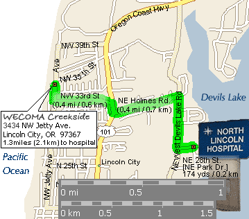
| 96.4mi | 155.20km | East Devils Lake Road junction with Hwy 101. Later in your stay, you may want to explore this road. There is a public park on the east side of the lake, and boat rentals and hospital on the west side. |
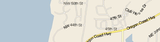
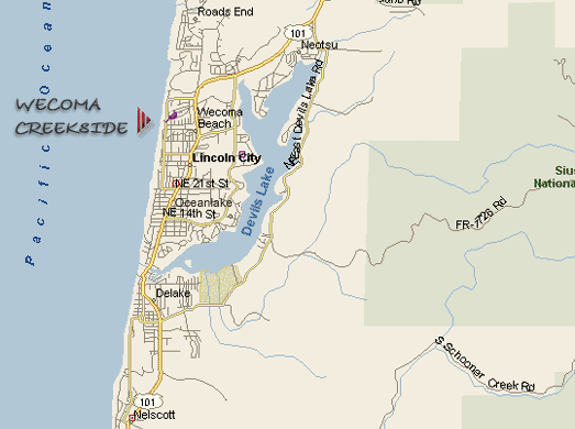
| 96.9mi | 156.01km | Major intersection of Hwy 101 and Logan Road. McDonalds on your left. On your right is Lighthouse Square (Lighthouse Brew Pub) as well as Safeway Plaza with lots of stores. |
| 97.0mi | 156.17km | Continue through this intersection, staying on Hwy 101 south, going about 300 feet. Turn right onto NW 36th, just past the "Coast Property" sign. |
| 97.2mi | 156.49km | Go 30 feet on NW 36th. The street splits into 4 options. Bear left, but not a hard left, onto NW 35th Place. |
| 97.4mi | 156.81km | Continue on NW 35th, then turn left onto NW Keel. (Dont go further on to NW Jetty. Thats the front of the house, and beach access and view, but no parking.) Go 100 feet south on NW Keel to 3434 NW Keel. |
| Arrival |
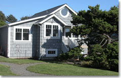
| You made it! Welcome to our family's beach house and guest cottage. |
 |
| Enter through the gate, walk down the path onto the patio, to the main entrance and into the utility.
Key is in lockbox on outside wall to right of entry door.
Security keypad is inside the house just to your right as you enter.
Tap in your code to disarm the alarm system. |
|
| Enjoy! |
|